- ● homepage
- ● archives
- ● restoration
- ● books
- ● big banners
- ● post board
- ■ neo's search
- ■ about us
- ■ 게재방법 안내
- 개인정보처리방침
- [email protected]
- Tel. 02_335_7922
- Fax. 02_335_7929
- 10:00am~04:30pm
- 월요일~금요일
- 3/3(월) 대체공휴일

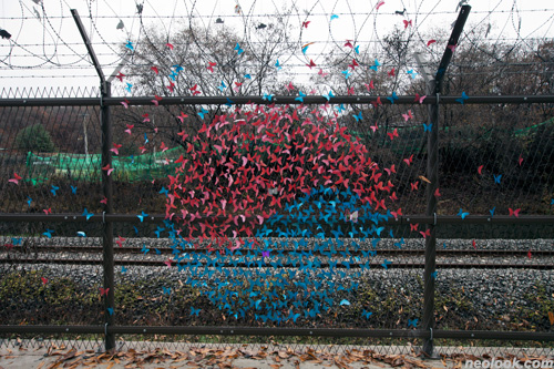
도라산권역 철책선 예술길 안내
박준식_이기일_양쿠라_정기현展 상설전시

별도의 초대일시가 없습니다.
주최 / 경기창작센터 후원 / 경기도 파주시_경기관광공사
관람시간 / 24시간 관람가능
도라산 민간인 통제구역 Dorasan within the Civilian Control Area
비무장지대에는 무엇이 기다리고 있는가? ● 한반도 분단은 제2차 세계대전 이후 미국과 구 소련에 의한 이원적 정치대립 구도가 남과 북에 구축되고, 서로 각각의 단독정부를 수립하면서 한민족이 분열되고 있는 현상이다. 물론 한국전쟁(1950-3)이 중요한 계기가 되었지만 비슷한 시기에 미·소의 분할통치체계 강화로 세계는 자유주의와 사회주의와의 대립 속에서 냉전 체계의 지배질서로 재편성되었고, 이러한 이원적 이데올로기는 한반도 분단이라는 공간적 분할에도 영향을 주었다. 1953년 7월 27일 정전협정에서 합의한 한국전쟁의 종전은 총 길이 250km, 폭 4km의 비무장지대라는 완충지대를 남겼다. 정전협정 제1권 협전문 제1조, 제1항에 따르면, "한 개의 군사분계선을 확정하고 쌍방이 이 선으로부터 각기 2km 후퇴함으로써 적대 군대간에 한 개의 비무장지대를 설정한다. 한 개의 비무장지대를 설정하여 이를 완충지대로 함으로써 적대행위의 재발을 초래할 수 있는 사건의 발생을 방지한다."고 언급된다. 이러한 과정 속에서, 비무장지대는 지난 60여년 간 남한과 북한이 서로를 적대적으로 인식하면서 철저하게 통제된 경계지역의 모습을 나타낸다. ● 이러한 점에 있어서, 비무장지대는 북위 38선을 넘나들며 동서를 횡단하는 물리적인 한반도 분단의 상징으로 인식되어 왔다. 하지만, 지난 60여년 동안 인간의 개입이 거의 없던 비무장지대는 자연 생태적으로 중요한 공간으로 여겨지면서, 한반도 두 국가의 정치적 갈등을 넘어 많은 비무장지대 자연환경의 관심이 지속되어 왔다. 한반도 미래를 통합적 관점에서 대안해볼 수 있는 역사적, 지리학적, 인류학적, 문화적 제언도 여러 번 있었다. 이러한 맥락에서, 현 비무장지대는 완충지대로서 소수의 도로와 철도가 연결되면서 남북의 경제교류가 가능하게 되었다. 또한, 비무장지대는 분단의 상징에서 통일의 원동력으로 큰 변화를 요구받고 있다. 동시대의 경계지대의 변화하는 조건 속에 비무장지대는 무엇이 될 수가 있을까? ● 궁극적으로, 우리의 테마 여행길 조성은, 비무장지대와 그 주변에 대한 대안적 미래를 그릴 수 있는 새로운 창의적인 생각 및 이해들을 가능하게 해 줄 것이다. 그리고 이러한 노력들은, 길을 걷는 사람들의 상상을 촉진하여 과거의 시간을 여행하기도 하고, 다수의 흥미로운 미래지향적인 가능성과 탐사를 한층 고무할 수 있을 것이다. ■ 경기창작센터 기획사업팀
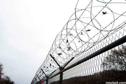
- 이기일_도라산 평화의 움직임_철책에 가변설치_2015

- 박준식_염원의 스톤_가변설치_2015

- 정기현_정전시계_가변설치_2015
- 양쿠라_날아라_가변설치_2015
What is waiting out the Korean demilitarized zone? ● The Korean demilitarized zone, hereafter the DMZ, which is a small strip of land between North and South Korea, occurred through the complete spatial division triggered after the Korean War (1950-3). Although the division has persisted affecting the make up of both Koreas, no other place symbolizes the absurdity of Korea's division more than the current DMZ. The DMZ actually refers to a border area heavily guarded for the last six decades. On July 27, 1953, an armistice agreement brought fighting in Korea's three-year conflict, though not the war itself, to an end. One legacy of that is a 250-km-long (155-mile) long strip of land which bisects the Korean peninsula into a northern and a southern half. The armistice agreement provided for a 4-km-wide (2.5-mile) buffer zone running west to east roughly along the 38th parallel. This buffer zone contains river deltas and grasslands toward its western end, but is mostly mountainous terrain in the east. According to the terms of the armistice agreement, there are to be no large troop placements in the area and all heavy weapons such as tanks and artillery pieces are banned. A fence marks the center along the Military Demarcation Line (MDL); the wider zone is known as the Demilitarized Zone (DMZ). Thus, the DMZ refers to two extremely militarized landscapes 4-km apart, that have been partially or fully mobilized to achieve military aims. After the civil war, the DMZ became littered with active land mines and frozen with armed force. The only permanent DMZ residents are soldiers from North and South Korea and observers from United Nation. The relationship between this borderline and the divided nations has always involved tedious decision making. Only a few roads and railroads have been reconnected within the DMZ to facilitate active spaces between the two states. ● Although the DMZ arose from political conflicts between one divided nation, the DMZ's identity continues to be debated and has been the focus of historical, geographic, ecologic, anthropologic and ethnographic studies for decades to determine social needs and interests. On the one hand, this continued interest is due to the future of Korea, which is based on Korea's historical context and problems, concerning the entire peninsular from a long-term perspective. As Korea's separation persists, the differences in North and South Korea's stances of history and culture will face continuous obstacles without this kind of joint historical interaction. On the other hand, the DMZ's existence continues to be a vital question in regard to its purely accidental nature of environmental protection. This 'no man's land' has turned into a protector of biodiversity on the Korean peninsula. Moreover, increasing urbanization and global warming require a nature conservation strategy that would provide land restoration and environmental security for the Korean peninsula. Amongst many previous studies and activities, there is another notable tendency that is also challenging the identity of the DMZ. The DMZ territory is now more than ever under pressure to change, as a result of proliferating economic transactions such as the DMZ security tourism and urbanization pressing from both North and South Korea. Imagining the DMZ's future in Korea, thus, lies more in the realm of gradual public accessibility than armed conflict. Reflecting on the diverse ways to think about the transformation of the DMZ is rethinking the future vision of the two Koreas and therefore considering the changing conditions of the contemporary border area in new historical perspectives. Only through this rigorously relational perspective to the historical process can the DMZ be envisioned as an immersion experience in which historical evidence constructively compels visitors to travel back in time by visualizing scenes from the past to enhance future orientation. This text is based on the master thesis “From demilitarized zone to publicly accessible park” of Seoyoung Kim, accepted at the Freie Universität Berlin in June, 2015. ■ Gyeonggi Creation Center
Vol.20151212h | 도라산권역 철책선 예술길 안내展